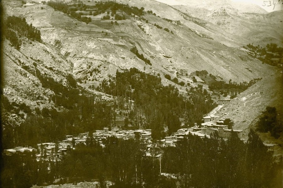
Located at the foothills of the Tauros, the territory of the kaza is mountainous, traversed by deep gorges, covered with pastures, meadows, and forest lakes. The East branch of the Tigris flows through the kaza with numerous tributaries.
Population
In the early 19th century, there were 95 villages in this kaza, of which 57[1] were Armenian-populated and the rest were Kurdish; the overall population was 8,433. Among the villages inhabited by Armenians were: Aregh (Առեղ), Arigum (Առիգոմ) Aroski (Առոսկի), Arevi (Արեհ), Armshat (Արմշատ), Ak’rus (Աքրուս), Bakhshkants Mazra (Բախչ կանց մազրա), Grmer (Գոմեր), Gotis (Գոտիս), Upper and Lower Darents (Verkin and Dayrents Nerk’in – Դարենց Վերին և Ներքին), Yeritsu Mazra (Երիցու մազրա), T’agh (Թաղ), Khumar (Խումար), Tsitsants (Ծիծանց), Tsugh (Ծուղ), Kaghagis (Կաղագիս), Kaghpi (Կաղպի), Kadjet’ (Կաճեթ), Kaynemeran (Կայնեմերան), Kasr (Կասր), Karader (Կարադեր), Kodjer (Կոճեր), Korich (Կոռիչ), Korovank’ (Կոռովանք), Kvers (կվերս), Hashkants (Հաշկանց), Higi (Հիգի), Hinents (Հինենց), Horis (Հորիս), Djamik (ճամիկ), Mardakerots (Մարդակերոց), Mardsegh (Մարծեղ), Maroshk’ (Մաքոշք), Muskaven (Մուսկավեն), Haro Mazra (Հարո մազրա), Nar (Նառ), Navahand (Նավահանդ), Shahrur (Շահրուր), Shamo Mazra (Շամո մազրա), Sheghdshants (Շեղջանց), Shidan (Շիդան), Shina Mazra (Շինա մազրա), Paghk’ (Պաղք), Paponts Mazra (Պապոնց մազրա), Puys (Պոլս), Dznuk (Ջնուկ), Mak (Մակ), Sarket’ (Սարկեթ), Soghvants (Սողվանց), Svtikin (Սվտիկին), Svtikin gomer (Սվտիկնա գոմեր), Vakhrov (Վախրով), Tghaspar (Տղասպար), P’aghents (Փաղենց), K’osents Mazra (Քոսենց մազրա), K’rments (Քրմենց)։
The residents of the district were engaged in artisanship, hunting, cattle breeding, bee keeping, cereals and other plant cultivation, gardening and vegetable growing.
At the turn of the 19th/20th centuries, there were Armenian schools in the towns of Shatakh/T’agh, Arshamat, Tsitsants, Kadshet, Znuk, and Hinents and in the villages.
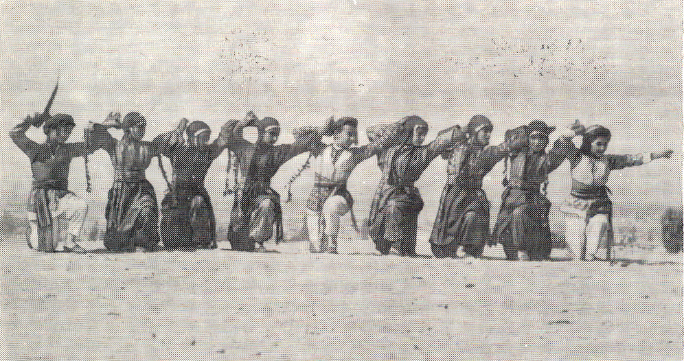
The Armenians of Shatakh preserved their semi-independence until the 19th century. In the 1870s, when a Kurdish provincial governor (vali) was appointed, Shatakh’s last Armenian prince, Mahtesi Mahak, had to leave the province of Van. The Armenian population of the town of Shatakh and the homonymous district took part in the self-defense of 1896 and 1915. The survivors the genocide fled and settled on the territory of present-day Armenia.
A number of medieval Armenian architectural monuments have been preserved in the kaza of Shatakh.(2)
Further listening: “Melody from Shatakh” (by Anna Hovhannisyan; source: Hayagitaran Hayastan. – https://www.youtube.com/watch?v=Qxv85kX6Uho
Shatakh (T’agh) town – Թաղ, Շատախ
History
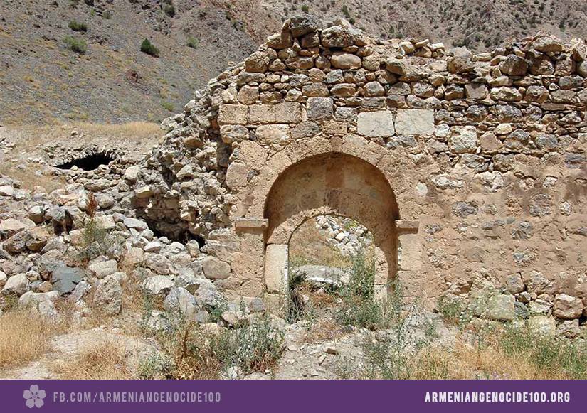
In the Middle Ages, Shatakh, as the center of the province of Moks (Moxoena, Moxoene), or Mokk’, had its fortress, which had fallen into ruins until modern times. At the beginning of the 19th century, the remains of the fortress and its church had been turned into barracks. The fortress was finally destroyed in 1850-1855 by Ottoman forces.
Population
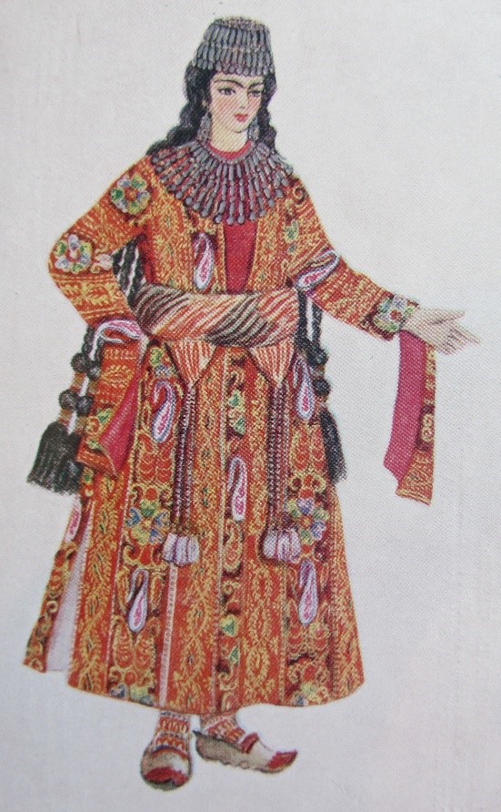
The residents of Shatakh were engaged in trade, constructing, bee keeping and horticulture. Shatakh was particularly famous for the manufacturing of shawls. The best choice of shawls, known as Van, was made from the wool of the Angora goats in Shatakh. A large number of women were involved in the shawl making; there were some warehouses and several homeowner enterprises.
The town had two Armenian churches: Right in the center of T’agh is St. John the Baptist (Surb Hovhannes Mkrtich; Karapet) from the 17th century, fundamentally rebuilt by Catholicos Khachatur II of Akhtamar in 1880-82, is a spacious three-aisled basilica, with two pairs of cross-shaped spheres and three apses to the east. On the left bank of the East Tigris stands Surb Stepanos Church (17th century), with a few columns on both sides of the apsis. It is a rather narrow, elongated hall church with sacristy.
About one kilometer to the north is the quite well preserved Church of the Holy Mother of God (Surb Astvadzadzin), a hall church with a few pillars and niches along the walls; its square apsis was unprecedented in Armenian architecture. Near the Church of the Holy Mother of God stands the Church of the Holy Trinity, also a hall church, which in the Middle Ages replaced an older building, the semi-oval pulpit of which was preserved in the eastern part of the church. To the south of this quarter, in today’s Kaşık village, lie two single-nave hall churches: The Church of the Our Lady (Surb Tikin; 14th century) is a well-preserved cupola hall. Southeast of it, on the bank of a tributary of the East Tigris, stands the Church of St. Sergios (Surb Sargis), also a cupola hall, with two mighty pillars and a rectangular apsis in the east. Conches form the transition from the rectangular substructure of the dome hall to the dome. The drum, which looks octagonal on the outside, is cylindrical on the inside.
In the 15th – 17th centuries some manuscripts were written in Shatakh, primarily gospels, at the end of which the scribes were mentioned. Two of the scribes in Shatakh were the priest Israel and Ohanes the elder.
Since the second half of the 19th century until the early 20th century, there was a school for boys and girls in Shatakh. With the help of a group of young people, a small newspaper was published here, containing mostly information on local life. There was also an amateur drama group.
The population of the settlement Shatakh or Tagh has never been more than a few thousand people. It was a purely Armenian-populated town, and at the beginning of the 19th century there were 3,500-4,000 inhabitants, and in the years preceding the First World War 1,200-1300 inhabitants. At present, Shatakh is an ordinary village. In 2012, the city’s population was 6,542 and mostly Kurds.
The German orientalist Carl-Friedrich Lehmann-Haupt (1861-1938), who had travelled to Northeast Armenia immediately after the Hamidian massacres of 1894-96 for research purposes, wrote about T’agh (Shatakh):
“For dinner, besides the usual chicken with rice, there were wonderful trout; supposedly the best that are widely available.
In this beautifully situated mountain town, almost exclusively inhabited by weavers, which provides the surrounding Kurds with the fabrics they need for their colorfully patterned garments, namely the wide trousers, we experienced it for the first and only time that the government authorities left the reception to be desired. (…)
The Bohtan-su or Shatakh-su, to which the Norduz-çay has now grown into, already often bears the name Tigris in the mouths of local residents. It is strengthened by an inflow, below whose mouth the trout, which we tasted, are caught (…).
In addition to its trout, Shatakh is also distinguished in culinary terms by its honey, which is said to be the best in Armenia.
Shatakh has been one of the few places where the Armenians did not let themselves be slaughtered by the Kurds without further ado, rather they had barricaded and defended themselves, despite the weapons ban, when Shakir-Agha with a large contingent of his people moved against the city, 400 men strongly in a big house, whereupon the cowardly murder gang, after they had plundered and burned some houses, moved on unfinished business.“[3]