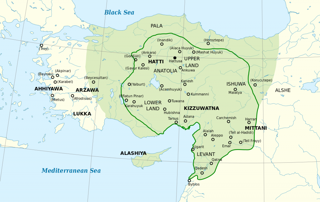
The city Malatya is located on the right bank of the Euphrates, about 10 km from the river, in a plain surrounded by mountains, about 940 m above sea level, southwest of the city of Harput. Historic Malatya was located 7-8 km south-west of modern Malatya.
The development of Malatya was facilitated by its convenient geographical location and almost always being an administrative center at different historical times. It was located on the ‘royal avenue’ of the ancient road connecting Susa, the capital of Persia, with the Mediterranean Sea. Later, caravan routes also passed through the city.
Administration
Before the proclamation of the independent state of Lesser Armenia (Փոքր Հայք – Pok’r Hayk’; literally “Little Armenia”) – Armenia Minor – (late 3rd century B.C.), Malatya was the center of one of its territories, which remained until the time of the Roman emperor Theodosios I (late 4th century), when Lesser Armenia was divided into two provinces: Armenia prima (Hayk’) with its center Sebastia (Trk.: Sivas), and Armenian secunda with Malatya (Melitene) center. During the reign of Emperor Justinian I (527-565), when Western Armenia and Lesser Armenia were subject to a new administrative division, the former Second Armenia (which expanded considerably at the expense of historic Cappadocia) was renamed Third Armenia, again with Malatya as its center. During Ottoman rule, Malatya and its environs first belonged to the historical Lesser Armenia and the province (vilayet) of Sebastia (Sivas), which included the Fourth Armenia, and when the latter was divided into two provinces, it became the center of the province of the same name, which included the south-eastern part of the former Sebastia province. In the 19th century Malatya was only the center of a sancak. It was included first in Maraş, and from the 1870s in the province of Harput.
The Ottoman sancak Malatya comprised the five kazas Malatya, Kahta, Hasanmansur / Adıyaman, Behisni, and Arga (also Ar(r)han, today: Akçadağ) .
Toponym
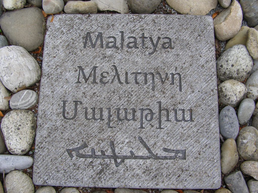
The place name goes back to the Hittite settlement Melid / Melidi / Meliddu / Milit / Malidiya, which is mentioned in Hittite sources since the 14th century B.C. Presumably, Melid means ‘honey’ and perhaps indicates the prosperity of this place. The Assyrians mentioned the settlement in the first millennium B.C. as Meliddu, Melide, Milid or Milidia, the Urartians as Meliṭeia.
According to the Pontic Greek historiographer and geographer Strabo, the city was known “to the ancients” as Melitene (Ancient Greek Μελιτηνή), a name adopted by the Romans following Roman expansion into the east.[1] The Turkish toponym is taken from the Arabic Malatiyye.[2] In Armenian, Malatya is also known as Meletine.
History
The Hittites had settled in the region around Malatya and founded a settlement called Melid on the hill Arslantepe (five kilometers from today’s city center). It became the capital of a regional Hittite kingdom.
With the fall of the Hittite Empire, the region around Melid was ruled by Kuzi-Teshshups of Karkemish, a grandson of Shuppiluliuma II, the last ruler of the Hittite Empire. His territory extended over the Malatya plain on the western bank of the Euphrates into Elbistan. In the east the government area was limited by Ishuva.
The Assyrian ruler Salmanaser (Shalmanaser) II undertook campaigns against the region around Melid in 844, 836 and 835 B.C. Under the ruler Tukulti-apil-Esharra III, Melid became tributary to the Assyrians. Around 800 B.C., when the Assyrian Empire was pressed harder by the kingdom of Urartu, Sargon II decided to hand over the city of Melid to the king of Kummuh. In 708 B.C., Melid was under direct Assyrian rule for three years. The Assyrian designations of the city as Meliddu, Melide, Milid or Milidia date from this period. By this time, however, control over Melid had already slipped from Assyria’s grasp, for under the rulers Sanherib and Assurhaddon further campaigns were waged against Melid, which the Assyrians, unable to control, ultimately burned to the ground. Only remains still point to the once flourishing city, a place that today is called Arslantepe. The new foundation, which initially continued to call itself Melid, was built elsewhere by the previous inhabitants.
According to Strabo of Amaseia, the inhabitants of Melitene shared with the nearby Cappadocians and Cataonians the same language and culture.[3]
Situated on the border of Urartu and Assyria, later Rome and Persia, then Byzantium and the Arab Caliphate, Malatya was repeatedly the scene of military conflicts, being destroyed and deprived of the opportunity to become a major city. Accordingly, in the following centuries, the rule over Melitene / Malatya is varied: from Persians and Seleucids it passed into the possession of the Romans, who moved the headquarters of Legio XII Fulminata here. When in 358 during the local synod Eustathios of Sebaste was deposed, this event took place in Melitene. Later, in 575, the Byzantine general Justinian was able to defeat the Persian Great King Khosrov I here in the famous Battle of Melitene. From the 6th century to 1069 the region belonged to Armenia Minor.
The short-term rule of the Armenian general in Byzantine service, Melias (Mleh) the Great, at the time of Emperor John I Tzimiskes ended with the Battle of Amida and the execution of Melias in 973. In 1069 Melitene fell to the Seljuks for the first time.
After the Byzantine defeat in the Battle of Manazkert (Manzikert) in 1071, Melitene once again passed to Byzantium. With the death of the distinguished Byzantine Armenian general Philaretos Brachamios (Greek: Φιλάρετος Βραχάμιος; Armenian: Փիլարտոս Վարաժնունի, Pilartos Varajnuni) or Vahram Varajnuni in 1090, the Armenian ruler Gabriel took power and established ties with the emerging Crusader states. When in 1103 the Danishmendids conquered Melitene, Gabriel was also killed during the fighting. Only three years later, the Seljuk prince Kılıç Arslan I was able to conquer Melitene. His death in 1107 and the capture of his son Malik Shah I made the youngest son Toghrul Arslan as well as his mother and her new husband, the Ortogrid Balak Ibn Bahram, rulers. The Seljuk medressa of Melitene was built by the Armenian master builder Tagavor (‘King’), “son of Stepan”. In 1124 Melitene was recaptured by Emir Ghazi for the Danishmendids. Since Emir Ghazi was considered a mild and just ruler, the local Christians were quite pleased with his assumption of power.
With the Mongol invasion in 1243, many inhabitants of Melitene sought their fortune in fleeing to Syria, but were almost entirely captured. It was only through the intervention of the Syriac Metropolitan Dionysos that a peace agreement with the Mongols was reached, under which Melitene was handed over to the Mongols without being plundered. Since 1273, Melitene was repeatedly attacked by Arabs and countless inhabitants of the surrounding villages were sold as slaves. In 1516 Malatya finally fell to the Ottomans.
The present location of the city was founded in 1838 as a military camp for the Ottoman army near the village of Asbuzu and quickly grew into a large industrial and commercial city. By the end of the 19th century, the third Malatya had 50 mosques and 10 churches.
In 1893, a strong earthquake killed 1300 people. It is therefore already the third city that was rebuilt, always only a few kilometers from the old settlement: Malatya emerged from the Melid of the Hittites and the medieval Melitene. Popularly known as Old Malatya (Eskimalatya), Old Malatya has been officially called Battalgazi since 1987. It is a water-rich city, springs flow in its different districts, and a river called Tukhma flows under its ruined wall.
Further Reading
For Malatya City see also the section ‘kaza Malatya’: https://virtual-genocide-memorial.de/region/the-six-provinces/harput-mamuret-uel-aziz-vilayet/sancak-malatya-melitene/kaza-malatya-melitene/
From the Krikor Guergerian archive: The Report of Captain Fazil Bey of 30 December 1918, to the Ministries of Interior and Justice, the Grand Vizierate and the Office of the Speaker: https://commons.clarku.edu/pd_fazil_bey/